
Zarqa River: Boundary of ancient kingdoms, route of travelers
Abdalrahem Alarjan, Jordan News

- +
- -
The Zarqa River winds through a history of key phrases
recalling the images of ages: kingdom boundaries, trade routes, a breadbasket,
the land of legends, chivalry, the seat of journeymen and scholars.اضافة اعلان
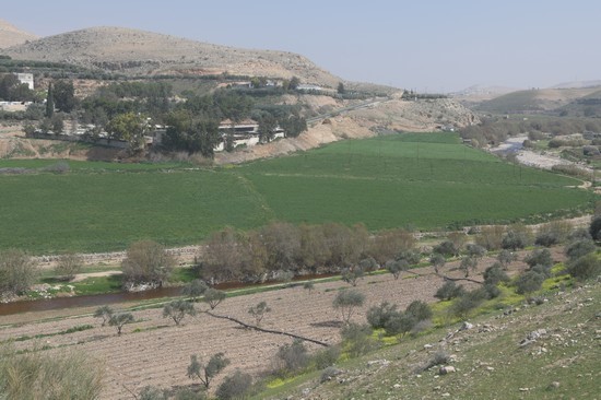
Our path to the north along the river began from the town of Birayn, an ancient historical village whose name, meaning “two wells”, derives from ancient wells discovered in the white rock, which dates back 80 million years to the Cretaceous period.
We gazed down from a viewpoint looking over Al-Dhulail and its canyons, between the hills where layers of limestone unfolded between curves of dolomite rock, punctuated with veins and cavities of flint. Geological processes had resulted in the presence of many fossils of marine creatures that went extinct after the sea receded and dried up.
Ottoman harvestThese fertile lands sprouted all varieties of fruits and field crops. They were once known for the great taxes poured from them during harvest seasons into the coffers of the Ottoman Empire. According to the empire’s Tapu records and the tax receipts documented in those days, three hundred silver akcheh were gleaned from those lands.
As we trekked, we were greeted by the plants that spring up at the end of winter, when nature displays its abundance. Bright Scorzonera jadaica covered the hills in yellow. We harvested enough to fill a plate to eat at the end of our trail — the edible part of the bulb is flavorful and resembles white turnips after its black skin is peeled away.
Later, we would have these with local eggs cooked in olive oil. Nature is inspiration — it is the secret to health.
Ancient kingdomsThose hills and mountains had witnessed the day when the kingdom of our Arab Ammonite ancestors was extinguished, when the bank of the river was the natural border separating the kingdoms of Sihon and Og.
After them, in the Roman Era, the river cut between the cities of Gerasa and Philadelphia, when an ancient road ran between them. The historian Josephus mentioned the river by its old name, Yabouq, derived from the baq-baq sound of the water beating against the many stones in the stream. Al-Hamawi referred to it by the well-known name Zarqa, when it was home to Shabib Al-Tabaai Al-Hamiri and his palace in the center of the city.
The kingdom remained for a short time, until the city eventually became a den of wild animals, hyenas, and leopards. In those days, another name was given to it, “Wadi Al-Masabaa”.
Explorers and travelersThe harsh terrain of the area speaks of the grit of those who live there, as mentioned by the Swiss traveler Burckhardt in his journey from Al-Madina to Istanbul in 1630 CE.
After him came Merrill, Musil, and the photographer Stein, and many other travelers and expeditions. The most famous name for the region at the time was Tal Al-Amarna.
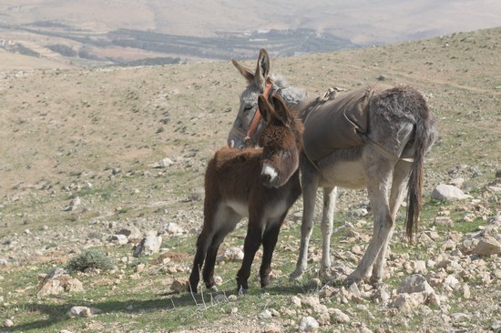
We continued our journey through a wide, green paradise of beans, onions, and lettuce. The place was a garden of eucalyptus trees that were planted by the Australian army during the World War I when they camped adjacent to the local farms.
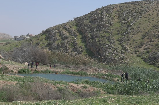
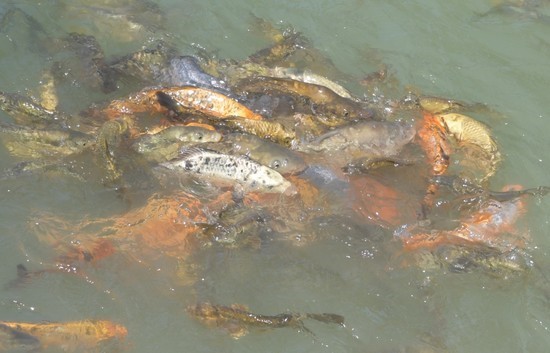
Local villagesThen, we passed through the center of Al-Khalah, where the river’s pure waters flowed to the outskirts of Al-Rahil and Abu Al-Zighan. Along the waters’ path, we found a pond that had become a natural fish farm and a destination for partridges, wild pigeons, and quail that hide their nests among the reeds.
We continued our path to the outskirts of the town of Duwaqarah, where a local bridge was built, which we crossed to the other side towards Ain Al-Nimra and Waida mountain. There is a town with the same name near Irbid.
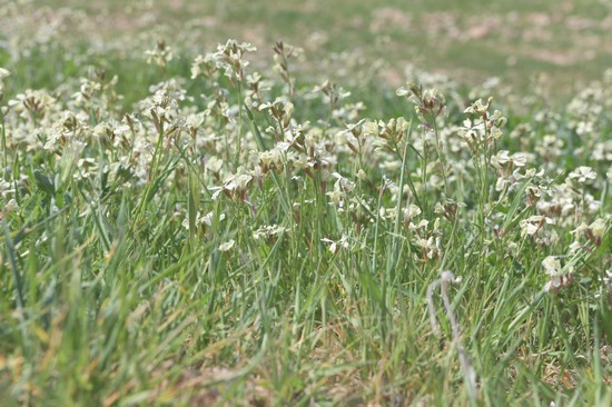
According to Greek myth, the bright red windflower dotting the region represents the blood of Adonis, who was killed by Zeus after he raged at his mistress, the beautiful Lady Venus. Meanwhile, other plants such as thyme and the first blooms of the milk thistle stood tall among the mallow leaves.
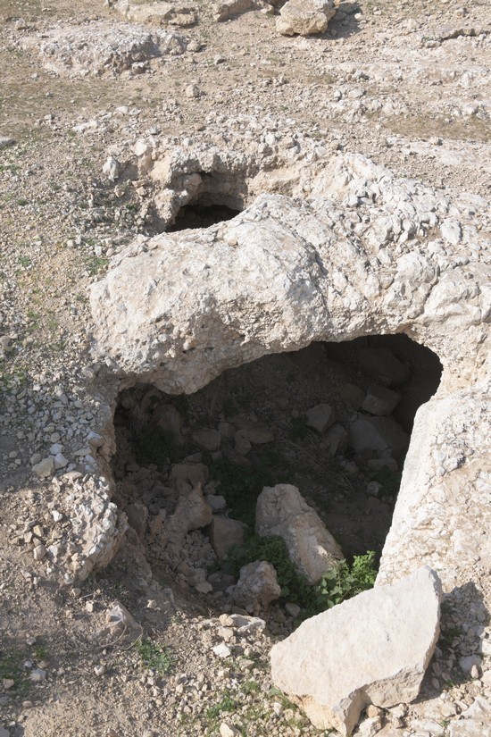
Ransacked ruinsFinally, we reached our historical destination, Tell Al-Wadaa and its ruins, nestled in the bosom of the mountain directly opposite to Duwaqarah. These ruins have not been precisely dated, but they consist of a complete town of dwellings, houses, and livestock pens. They were built of sharply-hewn local stones and interspersed with bricks taken from previous civilizations.
The fables tell that the Canaanite god of lightning once sat atop those hills, mounted on a bull, holding a lightning bolt in one fist and an axe in the other.
Finally at the end of our journey, we sat down to rest and prepare our food in peace. Our casual hike had brought us through 21km of history, legend, and bounteous nature.
Read more Yalla Jordan
Jordan News
Our path to the north along the river began from the town of Birayn, an ancient historical village whose name, meaning “two wells”, derives from ancient wells discovered in the white rock, which dates back 80 million years to the Cretaceous period.
We gazed down from a viewpoint looking over Al-Dhulail and its canyons, between the hills where layers of limestone unfolded between curves of dolomite rock, punctuated with veins and cavities of flint. Geological processes had resulted in the presence of many fossils of marine creatures that went extinct after the sea receded and dried up.
Ottoman harvestThese fertile lands sprouted all varieties of fruits and field crops. They were once known for the great taxes poured from them during harvest seasons into the coffers of the Ottoman Empire. According to the empire’s Tapu records and the tax receipts documented in those days, three hundred silver akcheh were gleaned from those lands.
As we trekked, we were greeted by the plants that spring up at the end of winter, when nature displays its abundance. Bright Scorzonera jadaica covered the hills in yellow. We harvested enough to fill a plate to eat at the end of our trail — the edible part of the bulb is flavorful and resembles white turnips after its black skin is peeled away.
Later, we would have these with local eggs cooked in olive oil. Nature is inspiration — it is the secret to health.
Ancient kingdomsThose hills and mountains had witnessed the day when the kingdom of our Arab Ammonite ancestors was extinguished, when the bank of the river was the natural border separating the kingdoms of Sihon and Og.
After them, in the Roman Era, the river cut between the cities of Gerasa and Philadelphia, when an ancient road ran between them. The historian Josephus mentioned the river by its old name, Yabouq, derived from the baq-baq sound of the water beating against the many stones in the stream. Al-Hamawi referred to it by the well-known name Zarqa, when it was home to Shabib Al-Tabaai Al-Hamiri and his palace in the center of the city.
These fertile lands sprouted all varieties of fruits and field crops. They were once known for the great taxes poured from them during harvest seasons into the coffers of the Ottoman Empire.
The kingdom remained for a short time, until the city eventually became a den of wild animals, hyenas, and leopards. In those days, another name was given to it, “Wadi Al-Masabaa”.
Explorers and travelersThe harsh terrain of the area speaks of the grit of those who live there, as mentioned by the Swiss traveler Burckhardt in his journey from Al-Madina to Istanbul in 1630 CE.
After him came Merrill, Musil, and the photographer Stein, and many other travelers and expeditions. The most famous name for the region at the time was Tal Al-Amarna.
We continued our journey through a wide, green paradise of beans, onions, and lettuce. The place was a garden of eucalyptus trees that were planted by the Australian army during the World War I when they camped adjacent to the local farms.
Local villagesThen, we passed through the center of Al-Khalah, where the river’s pure waters flowed to the outskirts of Al-Rahil and Abu Al-Zighan. Along the waters’ path, we found a pond that had become a natural fish farm and a destination for partridges, wild pigeons, and quail that hide their nests among the reeds.
We continued our path to the outskirts of the town of Duwaqarah, where a local bridge was built, which we crossed to the other side towards Ain Al-Nimra and Waida mountain. There is a town with the same name near Irbid.
The harsh terrain of the area speaks of the grit of those who live there, as mentioned by the Swiss traveler Burckhardt in his journey from Al-Madina to Istanbul in 1630 CE.The closer you are to the river, the greater the density of wormwood, which is considered one of the most important plants for detoxing the digestive system due to its superior ability to eliminate bacteria and fungi. From this plant was extracted the most well-known medicine for the treatment of malaria.
According to Greek myth, the bright red windflower dotting the region represents the blood of Adonis, who was killed by Zeus after he raged at his mistress, the beautiful Lady Venus. Meanwhile, other plants such as thyme and the first blooms of the milk thistle stood tall among the mallow leaves.
Ransacked ruinsFinally, we reached our historical destination, Tell Al-Wadaa and its ruins, nestled in the bosom of the mountain directly opposite to Duwaqarah. These ruins have not been precisely dated, but they consist of a complete town of dwellings, houses, and livestock pens. They were built of sharply-hewn local stones and interspersed with bricks taken from previous civilizations.
According to Greek myth, the bright red windflower dotting the region represents the blood of Adonis, who was killed by Zeus after he raged at his mistress, the beautiful Lady VenusAmong these buildings there are many large caves, some of which are connected to each other through winding catacombs. We entered three of them and found that past explorers had searched for treasures and tombs, excavating and destroying them.
The fables tell that the Canaanite god of lightning once sat atop those hills, mounted on a bull, holding a lightning bolt in one fist and an axe in the other.
Finally at the end of our journey, we sat down to rest and prepare our food in peace. Our casual hike had brought us through 21km of history, legend, and bounteous nature.
Read more Yalla Jordan
Jordan News
NEWS RELATED TO
Ajloun spring growth stimulates tourism
Mar 11,2023 | Where to Go