
Trekking the Aritayn trail, from desert waters to ancient volcano
By Abdalrahem Alarjan
Jordan News

- +
- -
Within Mafraq Governorate, south of the international road
linking Amman to Baghdad, two mountains signal the arrival of Jordan’s capital,
or bid farewell to those on their way to Anbar and the glorious capital of
Al-Rashid, Baghdad.اضافة اعلان
Due to the scarcity of shady areas along the path drawn out on our GPS applications, we divided our trip into two stages: the first from the town of Al-Bishriyya to the Usra Dam in the afternoon, pitching our tents for an overnight stay; and the second starting at dawn, to the two mountains and back.
After parking our cars in town, we set out on a direct southward path towards our day’s destination, Usra Dam, about nine kilometers away. We were trekking through desert filled with rare vegetation, except for the plants sprouting up on the edges of rainwater bodies, on a path covered with flint pebbles and black basalt.
That first leg of our journey was easy-going. As we walked, we welcomed the beginning of spring and the magic glow it casts upon the desert.
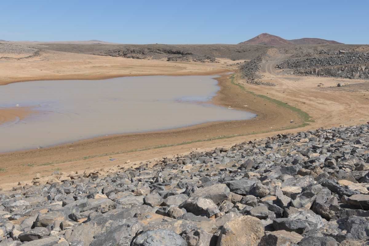
Camping along the damWe arrived at the dam, its aggregate walls paved with basalt stones, and pitched our tents at one of its corners. We had chosen a night on which the full moon of the month of Shaban illuminated the landscape, far from the lights and hustle and bustle of Jordan’s cities.
There, we contemplated stars and planets that do no appear clearly to the naked eye except in the canvas of the vast desert sky. The brilliance of the celestial bodies cast a sheen on the surface of the dam’s waters.
Some locals in a neighboring camp explained that Usra Dam was named “waters of hardship” after the scarcity of the precious resource in the desert. They said the dam had become a recreational destination for the people of nearby towns, and a prime spot to watch birds on their migration paths.
Nearby, we found some basalt rocks on which a number of clean inscriptions had been scrawled. Next to it, a modern etching showed a heart with the name of two lovers, to perpetuate their devotion for eternity.
Our camp was simple — a couple of one-man tents and sleeping bags, victuals for dinner and breakfast, sufficient water for coffee and drinking, and head lamps, which we had made sure to bring along for safety.
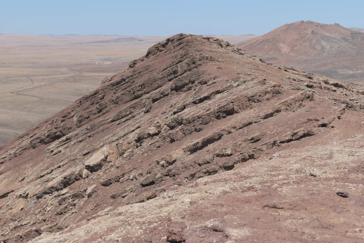
As soon as the first light of dawn came, we packed our luggage neatly so we could carry it taut on our shoulders, and set out towards the east in the direction of the Aritayn mountains, called “the lungs” in a local dialect due to the resemblance they bear to human lungs when viewed from above. They were first given the name by a British pilot who flew mail between Jordan and Iraq during the mandate.
According to the maps on our navigation devices, which offer coordinates with accurate height and distance measurements, the safest way to climb the peaks was from the southern side. The ascent required cautious foot placement due to the fragile clay tuff that crumbled under our steps and threatened slipping. To avoid this, we wore wide-soled shoes and used climbing sticks, carefully following the instructions of the trail leader who had once preceded us to ensure that we were taking a secure path. From base to peak, we gained about 200 meters of elevation, and found the difficulty level moderate.
Twin peaksAs soon as we reached the first summit, we took in a majestic scene blanketed in stillness. On the horizon were troughs, bodies of water separating us from Jabal Fahim and Jabal Hannoun, and to the north we spotted Jabal Qa’is and Jabal Maqa’is near the historical town of Umm Al-Quttayn and the famous Tal Ramah, rich in ore and zeolite formed as a result of volcanic activity. These minerals are of great agricultural importance, used to treat the soil and enhance its ability to release nitrogen and retain excess water, to reduce the irrigation needed especially for field crops.
The finest wheat grows in that area and serves as a rich source of particle minerals. That wheat is also used in industrial ponds for fish farming.
The scene beckoned us to stay and drink a cup of coffee from atop the volcano, which had become inactive at least a million years ago. A Japanese scientist called Aramaki had requested to include the site on UNESCO’s World Heritage List as a piece of natural heritage.
We continued on our way to the sister summit, walking the blade-like edge of the mountain along zigzags in between the two peaks. We crossed a natural separator dividing the duo, from which we could either descend or shorten the distance to our next target. We carried on.
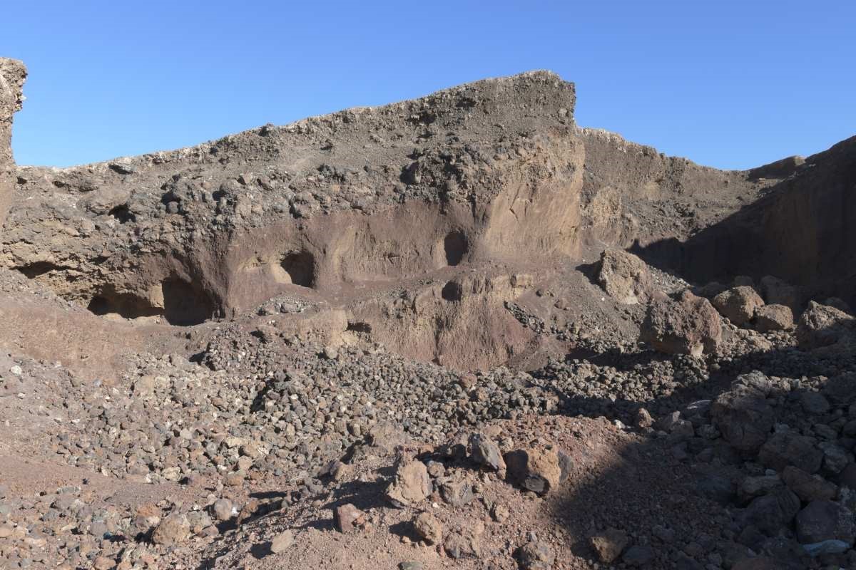
The second summit was no less spectacular than her sister, but rather, rose above by more than forty meters. We chose careful footings as we descended towards the vicinity of Al-Shifa, an abandoned quarry once used for the extraction of clay ore.
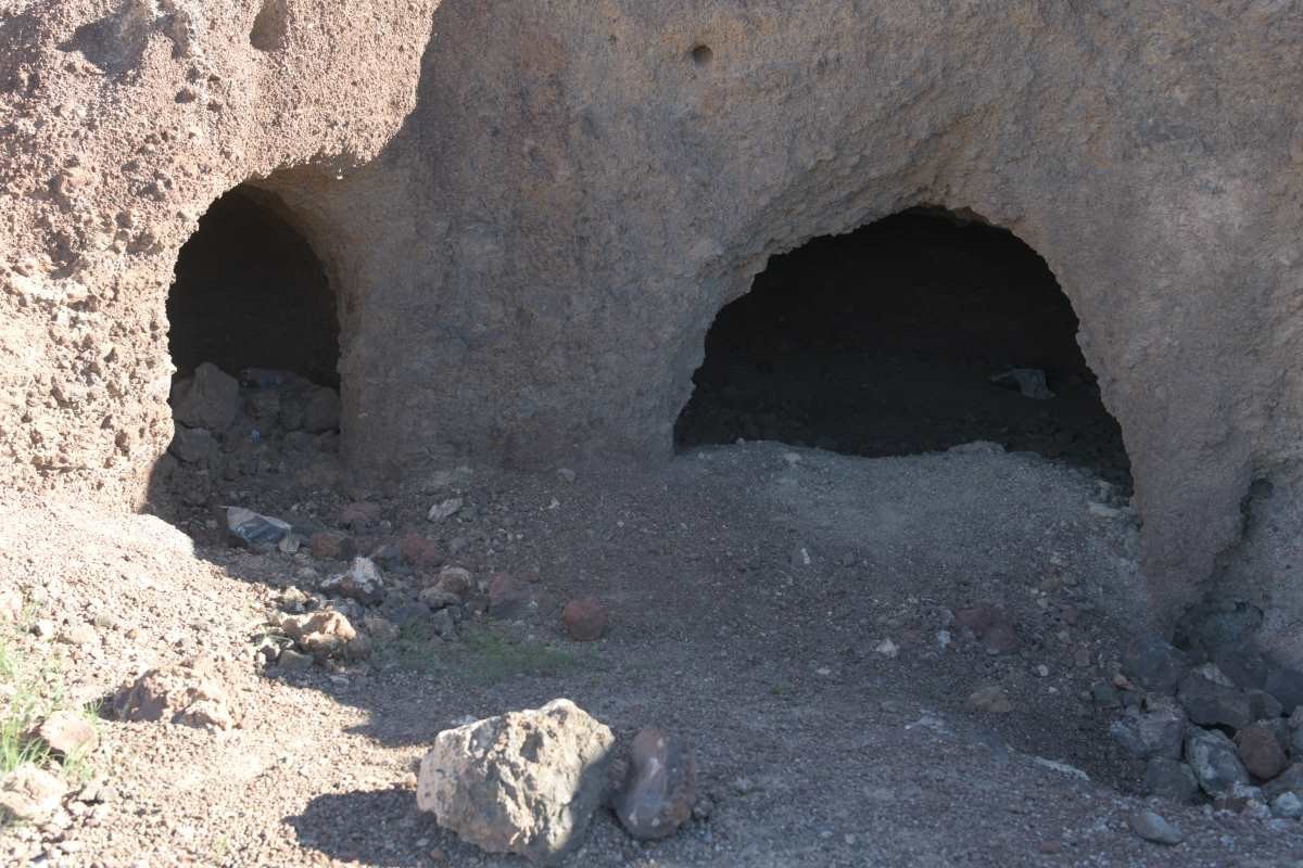
In the belly of the volcanoThe strangeness of the place invited us to explore, as the area allows you to enter the belly of the volcano, where gas bubbles have left cavities and crevices with multiple entrances and chambers that appeared after excavation, offering research opportunities for students of earth and mineral sciences.
Its appeal, however, is universal, for as soon as we published the pictures on social media, we received many calls from film producers asking for guided trips, enchanted by the site’s strangeness and uniqueness, and its potential as a location for filming, cinematic production, and documentary work.
We lingered there for a while, cautiously contemplating the dialogue of the sun, light, and shadows between the folds of the ancient volcano.
Then, we concluded our tour of this beautiful area, heading back towards our starting point, which we eventually reached to complete our 23-km trek.
Read more Where to Go
Jordan News
Due to the scarcity of shady areas along the path drawn out on our GPS applications, we divided our trip into two stages: the first from the town of Al-Bishriyya to the Usra Dam in the afternoon, pitching our tents for an overnight stay; and the second starting at dawn, to the two mountains and back.
After parking our cars in town, we set out on a direct southward path towards our day’s destination, Usra Dam, about nine kilometers away. We were trekking through desert filled with rare vegetation, except for the plants sprouting up on the edges of rainwater bodies, on a path covered with flint pebbles and black basalt.
That first leg of our journey was easy-going. As we walked, we welcomed the beginning of spring and the magic glow it casts upon the desert.
Camping along the damWe arrived at the dam, its aggregate walls paved with basalt stones, and pitched our tents at one of its corners. We had chosen a night on which the full moon of the month of Shaban illuminated the landscape, far from the lights and hustle and bustle of Jordan’s cities.
That first leg of our journey was easy-going. As we walked, we welcomed the beginning of spring and the magic glow it casts upon the desert.
There, we contemplated stars and planets that do no appear clearly to the naked eye except in the canvas of the vast desert sky. The brilliance of the celestial bodies cast a sheen on the surface of the dam’s waters.
Some locals in a neighboring camp explained that Usra Dam was named “waters of hardship” after the scarcity of the precious resource in the desert. They said the dam had become a recreational destination for the people of nearby towns, and a prime spot to watch birds on their migration paths.
Nearby, we found some basalt rocks on which a number of clean inscriptions had been scrawled. Next to it, a modern etching showed a heart with the name of two lovers, to perpetuate their devotion for eternity.
Our camp was simple — a couple of one-man tents and sleeping bags, victuals for dinner and breakfast, sufficient water for coffee and drinking, and head lamps, which we had made sure to bring along for safety.
As soon as the first light of dawn came, we packed our luggage neatly so we could carry it taut on our shoulders, and set out towards the east in the direction of the Aritayn mountains, called “the lungs” in a local dialect due to the resemblance they bear to human lungs when viewed from above. They were first given the name by a British pilot who flew mail between Jordan and Iraq during the mandate.
According to the maps on our navigation devices, which offer coordinates with accurate height and distance measurements, the safest way to climb the peaks was from the southern side. The ascent required cautious foot placement due to the fragile clay tuff that crumbled under our steps and threatened slipping. To avoid this, we wore wide-soled shoes and used climbing sticks, carefully following the instructions of the trail leader who had once preceded us to ensure that we were taking a secure path. From base to peak, we gained about 200 meters of elevation, and found the difficulty level moderate.
Twin peaksAs soon as we reached the first summit, we took in a majestic scene blanketed in stillness. On the horizon were troughs, bodies of water separating us from Jabal Fahim and Jabal Hannoun, and to the north we spotted Jabal Qa’is and Jabal Maqa’is near the historical town of Umm Al-Quttayn and the famous Tal Ramah, rich in ore and zeolite formed as a result of volcanic activity. These minerals are of great agricultural importance, used to treat the soil and enhance its ability to release nitrogen and retain excess water, to reduce the irrigation needed especially for field crops.
There, we contemplated stars and planets that do no appear clearly to the naked eye except in the canvas of the vast desert sky. The brilliance of the celestial bodies cast a sheen on the surface of the dam’s waters.
The finest wheat grows in that area and serves as a rich source of particle minerals. That wheat is also used in industrial ponds for fish farming.
The scene beckoned us to stay and drink a cup of coffee from atop the volcano, which had become inactive at least a million years ago. A Japanese scientist called Aramaki had requested to include the site on UNESCO’s World Heritage List as a piece of natural heritage.
We continued on our way to the sister summit, walking the blade-like edge of the mountain along zigzags in between the two peaks. We crossed a natural separator dividing the duo, from which we could either descend or shorten the distance to our next target. We carried on.
The second summit was no less spectacular than her sister, but rather, rose above by more than forty meters. We chose careful footings as we descended towards the vicinity of Al-Shifa, an abandoned quarry once used for the extraction of clay ore.
In the belly of the volcanoThe strangeness of the place invited us to explore, as the area allows you to enter the belly of the volcano, where gas bubbles have left cavities and crevices with multiple entrances and chambers that appeared after excavation, offering research opportunities for students of earth and mineral sciences.
We lingered there for a while, cautiously contemplating the dialogue of the sun, light, and shadows between the folds of the ancient volcano.
Its appeal, however, is universal, for as soon as we published the pictures on social media, we received many calls from film producers asking for guided trips, enchanted by the site’s strangeness and uniqueness, and its potential as a location for filming, cinematic production, and documentary work.
We lingered there for a while, cautiously contemplating the dialogue of the sun, light, and shadows between the folds of the ancient volcano.
Then, we concluded our tour of this beautiful area, heading back towards our starting point, which we eventually reached to complete our 23-km trek.
Read more Where to Go
Jordan News