
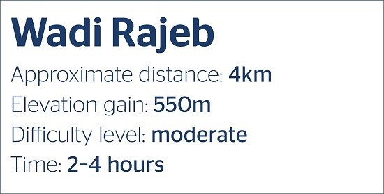
Hidden gem hike of the week: Wadi Rajeb
By Zane Wolfang, Jordan News

- +
- -
Our hike in Wadi Rajeb was the best we have done so far in
Jordan so far; the wadi is the true definition of a hidden gym, at least for
people coming from Amman. اضافة اعلان
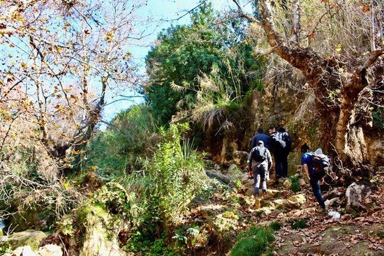
We saw a few locals along the way, and some friendly Harley riders from Jerash were entering the trail as we finished our loop and headed back to the car, so it appears that the trail is well used by people from the area.
(Photo: Zane Wolfang/Jordan News and Maggie Massie)
We parked at Muntaza Rajeb, which is on Google Maps (in Arabic) and easy enough to find after driving through the Rajeb village center, and walked straight through the park property to find the trailhead at the very back of it.
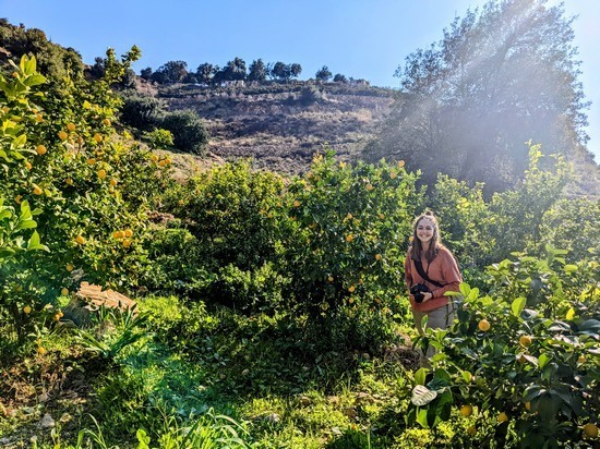
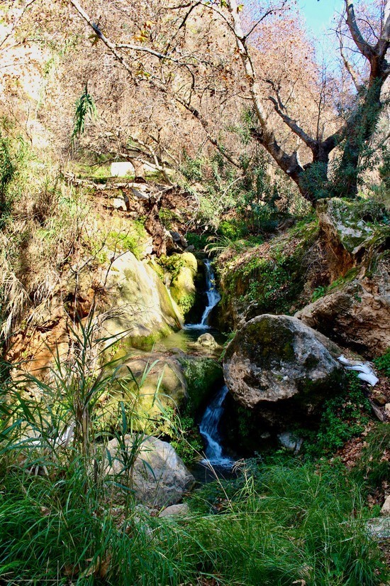
The park is built at the mouth of the wadi, and we walked a short but spectacular loop including a number of small waterfalls, sweeping views, lemon and olive groves, and an old church ruin before descending the same way we came and returning to the car. Even with quite a few stops to rest and admire different places along the way, and a brief detour where we tried to take a different path back along the northern side of the wadi and had to backtrack a bit to descend safely, the whole hike only took us three and a half hours. Everything we saw could easily be walked in two hours, but it was the type of hike that made us want to go slowly and savor the scenery.
(Photo: Zane Wolfang/Jordan News and Maggie Massie)
There are a few routes available to drive from Amman to Rajeb village, but the way I went both times I drove there is to head north to Jerash on route 35, then east on route 20 until a split in the town of Sakib, which takes you left and down into Wadi Rajeb.
There are quite a few shops and restaurants on both sides of the road in Sakib in case you are a bit unsure about which left to take and need to ask somebody, but the map directions should lead you there just fine.
We went on a Friday morning, but it might be better to go on a different day for your first time, as most of the village was busy with the Friday prayer when we arrived. We did not want to enter the park without local blessing, so we had to wait for a bit until the sermon concluded, at which point one of the park employees was kind enough to walk the very beginning of the trail with us and show us where to keep ascending.
(Photo: Zane Wolfang/Jordan News and Maggie Massie)
You can find the trail easily enough by yourself, as you basically follow the small river which runs through the bottom of the wadi, but I think it would be courteous to call the muntaza (+962 786 962 172) to let them know you are coming for a hike and would like to walk through their property in order to access the trail.
We had to get our feet a bit wet at times in the small brook which meanders across the wadi floor, but even now, at the peak of the rainy season, the wadi was not overflowing – it is spring fed year-round, with a big system of irrigation canals running through it, and is not like the southern wadis which flood in the winter and even in the summer require hikers to submerge much of their bodies in water.
(Photo: Zane Wolfang/Jordan News and Maggie Massie)
In some ways, the very beginning of the trail is the trickiest part, as the it crosses the small brook several times and requires a bit of scrambling over some slippery rocks. None of that portion is steep, as it is down in the bottom of the wadi, so it is not particularly dangerous, but it does require some focus and careful stepping to avoid slipping.
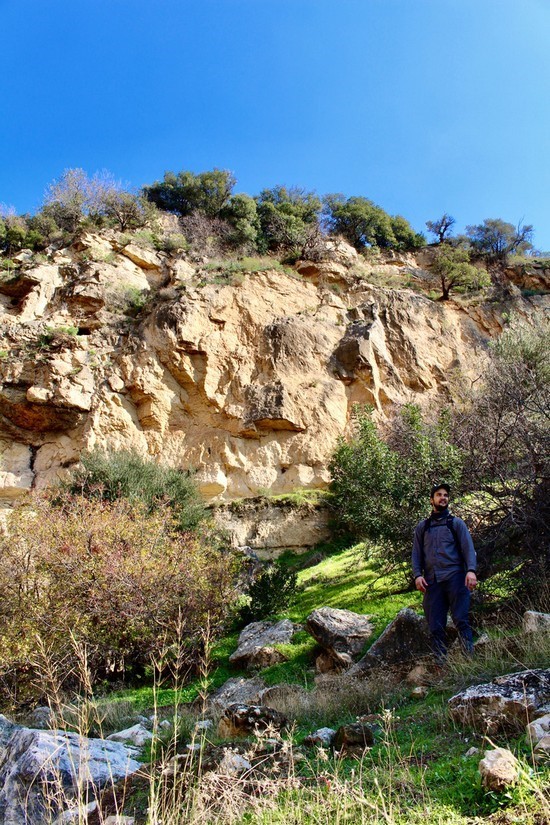
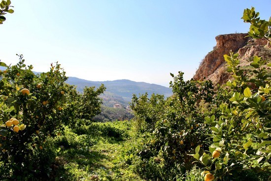
We had originally intended to stop our hike at a church ruin that the locals call Deir Mesmar – local lore claims that the ruin was discovered by King Abdallah while he was serving in the Special Forces. The ruin is fully encircled by a fence on a farmer’s field and is probably the highest point of the hike. From there, you have the option to either retrace your steps down the trail, or return on the backroads through the town, which is full of fruit farms and would also be quite a lovely walk.
(Photo: Zane Wolfang/Jordan News and Maggie Massie)
However, we found that the trail continued for a short while after the ruin, and led to some very nice freshwater pools and large boulder formations. To our delight, and to my immense surprise as somebody who grew up exploring the saltwater scenes of the Atlantic coast, one of the pools we stopped at was the home of a fairly large crab. Some research revealed that it was most likely Potamon potamios, subspecies palaestinense. We also saw some different birds and waited by a waterfall at one point to allow a herd of goats to pass above us on the trail, but the crab was absolutely the wildlife highlight of the day.
I added Deir Mesmar to Google Maps after my first trip to Rajeb, and recorded our hike under the name “Wadi Rajeb to Deir Mesmar (+ Graffiti Beach)” on the Wikiloc app. The Wikiloc recording is more helpful as a rough guide than as an exact route, since our group took a fairly obvious detour to nowhere and had to turn around to get back to the trail at one point. If you do choose to return via the north side of the wadi instead of retracing exact steps via the south side, there is a path back down to the brook through the olive terraces, but no obvious descent after them.
When you get back to the muntaza, there are places to sit and rest, as well as some food and drinks for sale at the building close to the parking lot.
This hike was easy to get to, fun to do, and absolutely spectacular. Happy hiking from the Hidden Gem Hikers!
Read more Around Jordan
We saw a few locals along the way, and some friendly Harley riders from Jerash were entering the trail as we finished our loop and headed back to the car, so it appears that the trail is well used by people from the area.
(Photo: Zane Wolfang/Jordan News and Maggie Massie)
We parked at Muntaza Rajeb, which is on Google Maps (in Arabic) and easy enough to find after driving through the Rajeb village center, and walked straight through the park property to find the trailhead at the very back of it.
The park is built at the mouth of the wadi, and we walked a short but spectacular loop including a number of small waterfalls, sweeping views, lemon and olive groves, and an old church ruin before descending the same way we came and returning to the car. Even with quite a few stops to rest and admire different places along the way, and a brief detour where we tried to take a different path back along the northern side of the wadi and had to backtrack a bit to descend safely, the whole hike only took us three and a half hours. Everything we saw could easily be walked in two hours, but it was the type of hike that made us want to go slowly and savor the scenery.
(Photo: Zane Wolfang/Jordan News and Maggie Massie)
There are a few routes available to drive from Amman to Rajeb village, but the way I went both times I drove there is to head north to Jerash on route 35, then east on route 20 until a split in the town of Sakib, which takes you left and down into Wadi Rajeb.
There are quite a few shops and restaurants on both sides of the road in Sakib in case you are a bit unsure about which left to take and need to ask somebody, but the map directions should lead you there just fine.
We went on a Friday morning, but it might be better to go on a different day for your first time, as most of the village was busy with the Friday prayer when we arrived. We did not want to enter the park without local blessing, so we had to wait for a bit until the sermon concluded, at which point one of the park employees was kind enough to walk the very beginning of the trail with us and show us where to keep ascending.
(Photo: Zane Wolfang/Jordan News and Maggie Massie)
You can find the trail easily enough by yourself, as you basically follow the small river which runs through the bottom of the wadi, but I think it would be courteous to call the muntaza (+962 786 962 172) to let them know you are coming for a hike and would like to walk through their property in order to access the trail.
We had to get our feet a bit wet at times in the small brook which meanders across the wadi floor, but even now, at the peak of the rainy season, the wadi was not overflowing – it is spring fed year-round, with a big system of irrigation canals running through it, and is not like the southern wadis which flood in the winter and even in the summer require hikers to submerge much of their bodies in water.
(Photo: Zane Wolfang/Jordan News and Maggie Massie)
In some ways, the very beginning of the trail is the trickiest part, as the it crosses the small brook several times and requires a bit of scrambling over some slippery rocks. None of that portion is steep, as it is down in the bottom of the wadi, so it is not particularly dangerous, but it does require some focus and careful stepping to avoid slipping.
We had originally intended to stop our hike at a church ruin that the locals call Deir Mesmar – local lore claims that the ruin was discovered by King Abdallah while he was serving in the Special Forces. The ruin is fully encircled by a fence on a farmer’s field and is probably the highest point of the hike. From there, you have the option to either retrace your steps down the trail, or return on the backroads through the town, which is full of fruit farms and would also be quite a lovely walk.
(Photo: Zane Wolfang/Jordan News and Maggie Massie)
However, we found that the trail continued for a short while after the ruin, and led to some very nice freshwater pools and large boulder formations. To our delight, and to my immense surprise as somebody who grew up exploring the saltwater scenes of the Atlantic coast, one of the pools we stopped at was the home of a fairly large crab. Some research revealed that it was most likely Potamon potamios, subspecies palaestinense. We also saw some different birds and waited by a waterfall at one point to allow a herd of goats to pass above us on the trail, but the crab was absolutely the wildlife highlight of the day.
I added Deir Mesmar to Google Maps after my first trip to Rajeb, and recorded our hike under the name “Wadi Rajeb to Deir Mesmar (+ Graffiti Beach)” on the Wikiloc app. The Wikiloc recording is more helpful as a rough guide than as an exact route, since our group took a fairly obvious detour to nowhere and had to turn around to get back to the trail at one point. If you do choose to return via the north side of the wadi instead of retracing exact steps via the south side, there is a path back down to the brook through the olive terraces, but no obvious descent after them.
When you get back to the muntaza, there are places to sit and rest, as well as some food and drinks for sale at the building close to the parking lot.
This hike was easy to get to, fun to do, and absolutely spectacular. Happy hiking from the Hidden Gem Hikers!
Read more Around Jordan
NEWS RELATED TO
Hidden gem hike of the week : The ‘Ale Trail’
Jan 19,2022 | Where to Go