
Mesa Trail, the beginning of civilization on summitless mountains
Abdulrahim Al-Arjan, Jordan News

- +
- -
To the south and east of Amman, near Al-Azraq and not far from the Saudi border, are dark, basalt-like mountains without
summits which served as the refuge for the first human to establish
civilization and settle in the Jordanian Badia. The beginnings of secrets and
histories.اضافة اعلان
After we made camp near the Rajal Dam, we hurriedly raced the early morning rays towards Qatafi Dam to save time before the heat intensified. We drove freely on unpaved roads, relying on the driver's expertise and the convoy leader's instructions to deal with varying elevations and tough terrain.
Qatafi Dam
After a 40km drive, we reached our destination, the Qatafi Dam, entering a phase where mobile networks were no longer available. We relied on our path marking, land navigation apps, and a Garmin GPS device. After having breakfast on the dam's rubble body, we began our hike towards the Maytland Mesa Mountains, named by the British pilot who documented them in 1926.
The vastness of the land, with its abundant reeds and tributaries, fascinated me due to the purity of its soil, suitable for making pottery, fine ceramics, and souvenirs. To the north of it, there is a well with the same name, as well as an imposing hill.
Mesa mountains
It is a place that arouses the sublime, with its dark mountains covered in basalt, and an average elevation difference of 100m between the summit and the base.
Many of the various paths leading to its peak, among sheets and blocks of stone, impressively do not require special climbing equipment. At the base, we spotted a paved house or warehouse with a height not exceeding one meter, meticulously documented by archaeological surveys.
This mountain is one of 20 scientifically documented peaks. We climbed six of them, but this one was the most integrated settlement established approximately 8000 years ago. It may have been the beginning of civilization, social stability, and tribe-building in this region. Although it lacks the engravings found on other mountains we climbed along our 14km journey, it holds historical significance.
At the bare summit, we were awestruck again by the natural scenery and how it was ingeniously formed. If you let your imagination wander for thousands of years, you might envision volcanic rocks falling from the sky setting the land on fire. Like the land of torrents and floods during winter, there is no escape from its grasp except at the edges of the mountains.
The fortified summit, limited in space, is surrounded by cylindrical towers, tombs, and rocky barriers, with a single entrance leading to it. It housed archaeological missions that did not explore it until a few years ago, due to the difficult terrain and harsh environment. They discovered stone arrowheads, daggers, grinding tools for grains, in addition to massive cylindrical tombs and houses constructed with a blend of vertical and flat stones without trimming or mud.
Wadi Subhi
After completing the ascent of six mountains and walking through a portion of the valley, we completed our journey to Wadi Subhi, the destination of the shepherds and the solitude of the Bedouins. It is 100m higher than Wadi Qatafi and offers a different natural diversity and denser vegetation, entirely distinct from the area we previously visited.
It is known for the quality and taste of its livestock's meat, as well as the production of milk, cheese, and ghee, all of which are nurtured by the landscape.
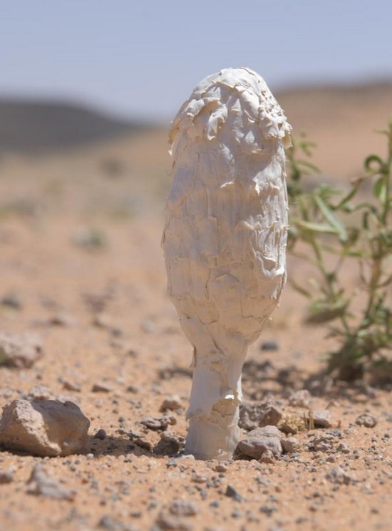
The remarkable diversity of the landscape includes pinkish sand carried by the winds from the Hassam and the Empty Quarter deserts. In this sandy soil, the desert truffles grow, known for their effectiveness in treating male infertility when consumed fresh with honey. Between the hills, we had the joy of riding the sandboard, competing to balance on it for longer distances.
That night, we set up our camp amid warm shrubs, sheltering us from the chilly nights of the dry month of May. A saying goes, "The cold of the valleys melts the mountains," and it is not far from the herders' pastures. They kindly visited us, checking our tents and telling us about the place's mysteries, its hidden gems, and the reasons behind its names. They returned to us the next morning, showing the hospitality of the desert people, sharing their cheese and local ghee, products of their livestock.
Al-Shumaysaniat
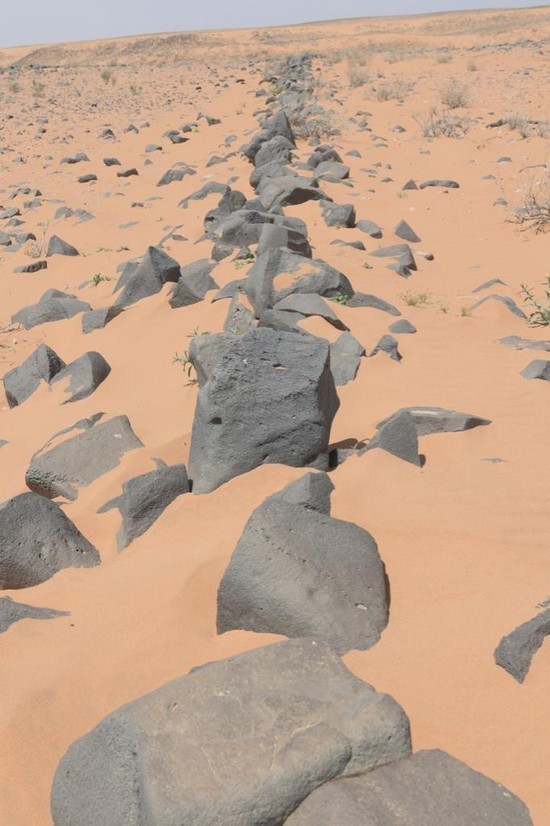
We bid farewell to our hosts, heading east in our cars, traversing a dirt road parallel to single and double stone walls and columns visible as far as the eye can see. They are entirely different from the historical traps and 100m high fault cliffs, which separate the layers of earth that separated millions of years ago due to earthquakes and volcanoes, known as the Fulaq Rift.
We reached "Al-Shumaysaniat," the three unique mountains in the Pink Plain that extend eastward towards the Saudi border, 15 km away. They converged with the Mesa Mountains, containing different engravings from what we found in Mount Qarma in terms of techniques.
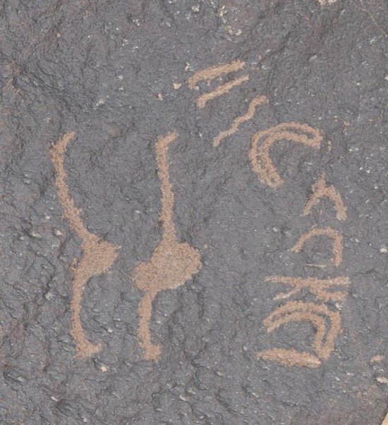
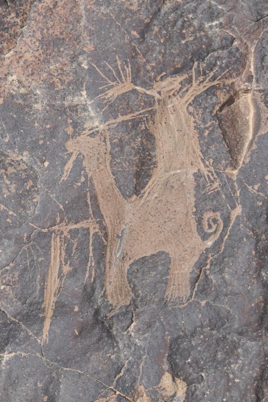
They used an engraved style with clear lines or delineated drawings, followed by carving with dotting. One of the remarkable depictions was one of groups of ostriches and camels on the same stone. It seemed to indicate their abundance during that time. there were some people depicted proudly displaying their horsemanship skills, riding horses with reins or riding camels, brandishing spears, or dancing with their camels, as evident from the movement of their legs. It is not unlikely that the art of sound and the dance of Al-Dhahiya began here, deriving its tones from the calls of wildlife.
After completing the ascent of the three mountains, each with a height of 850m, 150m above the base, we accidentally found a location not far from them with some pottery fragments dating back to the Roman era, judging from the firing techniques.
Finally, we returned to our starting point, Al-Azraq Castle, completing an exciting journey full of pleasure and adventure, covering a distance of about 170km by safari and 46km on foot, in stages of varying difficulty of walking and driving and spending two nights in the wilderness under the Badia's atmosphere. We reached places rarely visited by anyone.
Read more Around Jordan
Jordan News
After we made camp near the Rajal Dam, we hurriedly raced the early morning rays towards Qatafi Dam to save time before the heat intensified. We drove freely on unpaved roads, relying on the driver's expertise and the convoy leader's instructions to deal with varying elevations and tough terrain.
Qatafi Dam
After a 40km drive, we reached our destination, the Qatafi Dam, entering a phase where mobile networks were no longer available. We relied on our path marking, land navigation apps, and a Garmin GPS device. After having breakfast on the dam's rubble body, we began our hike towards the Maytland Mesa Mountains, named by the British pilot who documented them in 1926.
The vastness of the land, with its abundant reeds and tributaries, fascinated me due to the purity of its soil, suitable for making pottery, fine ceramics, and souvenirs. To the north of it, there is a well with the same name, as well as an imposing hill.
Mesa mountains
It is a place that arouses the sublime, with its dark mountains covered in basalt, and an average elevation difference of 100m between the summit and the base.
Many of the various paths leading to its peak, among sheets and blocks of stone, impressively do not require special climbing equipment. At the base, we spotted a paved house or warehouse with a height not exceeding one meter, meticulously documented by archaeological surveys.
This mountain is one of 20 scientifically documented peaks. We climbed six of them, but this one was the most integrated settlement established approximately 8000 years ago. It may have been the beginning of civilization, social stability, and tribe-building in this region. Although it lacks the engravings found on other mountains we climbed along our 14km journey, it holds historical significance.
At the bare summit, we were awestruck again by the natural scenery and how it was ingeniously formed. If you let your imagination wander for thousands of years, you might envision volcanic rocks falling from the sky setting the land on fire. Like the land of torrents and floods during winter, there is no escape from its grasp except at the edges of the mountains.
The fortified summit, limited in space, is surrounded by cylindrical towers, tombs, and rocky barriers, with a single entrance leading to it. It housed archaeological missions that did not explore it until a few years ago, due to the difficult terrain and harsh environment. They discovered stone arrowheads, daggers, grinding tools for grains, in addition to massive cylindrical tombs and houses constructed with a blend of vertical and flat stones without trimming or mud.
Wadi Subhi
After completing the ascent of six mountains and walking through a portion of the valley, we completed our journey to Wadi Subhi, the destination of the shepherds and the solitude of the Bedouins. It is 100m higher than Wadi Qatafi and offers a different natural diversity and denser vegetation, entirely distinct from the area we previously visited.
It is known for the quality and taste of its livestock's meat, as well as the production of milk, cheese, and ghee, all of which are nurtured by the landscape.
The remarkable diversity of the landscape includes pinkish sand carried by the winds from the Hassam and the Empty Quarter deserts. In this sandy soil, the desert truffles grow, known for their effectiveness in treating male infertility when consumed fresh with honey. Between the hills, we had the joy of riding the sandboard, competing to balance on it for longer distances.
That night, we set up our camp amid warm shrubs, sheltering us from the chilly nights of the dry month of May. A saying goes, "The cold of the valleys melts the mountains," and it is not far from the herders' pastures. They kindly visited us, checking our tents and telling us about the place's mysteries, its hidden gems, and the reasons behind its names. They returned to us the next morning, showing the hospitality of the desert people, sharing their cheese and local ghee, products of their livestock.
Al-Shumaysaniat
We bid farewell to our hosts, heading east in our cars, traversing a dirt road parallel to single and double stone walls and columns visible as far as the eye can see. They are entirely different from the historical traps and 100m high fault cliffs, which separate the layers of earth that separated millions of years ago due to earthquakes and volcanoes, known as the Fulaq Rift.
We reached "Al-Shumaysaniat," the three unique mountains in the Pink Plain that extend eastward towards the Saudi border, 15 km away. They converged with the Mesa Mountains, containing different engravings from what we found in Mount Qarma in terms of techniques.
They used an engraved style with clear lines or delineated drawings, followed by carving with dotting. One of the remarkable depictions was one of groups of ostriches and camels on the same stone. It seemed to indicate their abundance during that time. there were some people depicted proudly displaying their horsemanship skills, riding horses with reins or riding camels, brandishing spears, or dancing with their camels, as evident from the movement of their legs. It is not unlikely that the art of sound and the dance of Al-Dhahiya began here, deriving its tones from the calls of wildlife.
After completing the ascent of the three mountains, each with a height of 850m, 150m above the base, we accidentally found a location not far from them with some pottery fragments dating back to the Roman era, judging from the firing techniques.
Finally, we returned to our starting point, Al-Azraq Castle, completing an exciting journey full of pleasure and adventure, covering a distance of about 170km by safari and 46km on foot, in stages of varying difficulty of walking and driving and spending two nights in the wilderness under the Badia's atmosphere. We reached places rarely visited by anyone.
Read more Around Jordan
Jordan News