
Why a simple photo has started a debate about Amman
The city’s sprawling concrete facade has divided opinions, but it was never really meant to be
By Nayrouz Ali, Jordan News

- +
- -
For the past few days, Jordanians have been busy talking
about a picture of the capital taken from an airplane by Jude Al-Safadi.
Posted with the caption read: “These lego pieces hold my whole life, every human I’ve ever known, the home I’ve lived in my whole life, so many lives and it’s all as small as a pixel, so trivial and yet so significant. It’s a beautiful dichotomy.”اضافة اعلان
What Safadi probably didn’t expect is the influence the picture would have and the debate it would stir. Some found it a beautiful documentation of their city, while others described it as “ugly”, “suffocating”, or even “a terrible catastrophe of urban planning”.
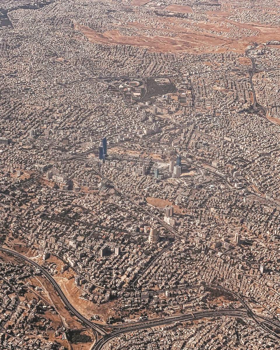
A photograph of Amman taken by Jude Al-Safadi. Responses to the photo ranged from positive to negative concerning Amman’s appearance. (Photos: Jude Al-Safadi’s Facebook page)
The aerial picture doesn’t offer that different of a perspective from walking around the city: the absence of greenery and public spaces isn’t a surprise and who could miss the cubes of cement that are Amman’s buildings, along with the never ending sprawl and emerging of new “centers”.
To many, Amman is missing the basic features of a city, which make it look like a small village that kept growing until it became a huge village, but to be fair, isn’t that what technically happened?
In order to reach a better understanding or perhaps offer solutions, it is important to be familiar with the timeline of the city.
Amman as we know it today is only a 100 years old, which means it is still a baby compared to other cities in the region, yet it is the Middle East’s fastest growing city.
Although it dates back to 7,000 BC and was known as Rabbath Ammon, the capital of the Ammonite civilization, before becoming Philadelphia under Roman rule and then becoming abandoned in the 15th century.
It is worth mentioning that there were bedouins in the area, but the bedouin lifestyle required continuous movement and no need for cities or urban spaces.
It wasn’t until 1878 that Amman was reinhabited, when Circassians settled in the valley near the Roman Theater and Amman Citadel, which shaped the city’s very first urban space.
By 1900, Amman could be considered a proper village, with people building houses up the mountains surrounding the valley and creating a new urban pattern.
After 1916 and the Arab Great Revolt against the Ottomans, The Emirate of Transjordan was established in 1921 and a transfer of authority gradually took place.
By that time, buildings had started to crowd the area around the Husseini Mosque, which was becoming the center of the village’s growth.
After the Jordan River Earthquake of 1927, many buildings were demolished and people lost their lives, leaving many to start building on top of the surrounding mountains.
During the 30s and 40s, the emerging city attracted Palestinian, Syrian, and Lebanese merchants who went on to build the city’s oldest villas.
In 1946 and after the full independence, the first government of Jordan came into existence and brought with it new functions, positions, and social classes.
The Palestinian Nakba in 1948 (or catastrophe, which refers to the 1948 Arab-Israeli war and the loss of Palestine), further brought huge numbers of refugees, the population almost doubled in numbers, however, city planning had been absent since the city was reestablished.
The refugee influx resulted in a swelling modern city with the lines of eastern and western Amman beginning to be drawn. Driven by modernism and access to vehicles, the city’s design began to take shape as one built for cars rather than humans and pedestrians.
More Palestinian refugees came with the Naksa (or setback, referring to the1967 Arab-Israeli war and Arab loss), and the refugee camps in Amman became permanent, leaving entire neighborhoods were never planned to be there.
The “spine” of Amman, the main circles from the first to the eight, was built in 1970 as an attempt to draw clear outlines and somehow connect the city’s chaotic neighborhoods.
The 1992 Gulf War and the Iraq invasion in 2003 also brought a sudden influx of refugees.
The constant spikes in the city’s population were never planned for, and the village of Amman was forced to become a city that was never planned for.
In 2002, the Greater Amman Municipality (GAM) was established to organize the chaos city, and it brought with it a data base for land use and worked on projects to remove stalls, while still somehow preserving a defined identity.
One of GAM’s regulations was that 15 percent of the city’s built area has to be green,. However, many people have questioned if this actually being applied in reality due to the absence of greenery.
It might be difficult to create a master plan and impose parks and public spaces in an already existent city, but it isn’t impossible.
The first step might be to stop or control the growth of the suburbs of the city, which become nothing but lifeless blocks that will be swallowed up by the city within few years when it continues to expand even more.
Read more Trending
Posted with the caption read: “These lego pieces hold my whole life, every human I’ve ever known, the home I’ve lived in my whole life, so many lives and it’s all as small as a pixel, so trivial and yet so significant. It’s a beautiful dichotomy.”
What Safadi probably didn’t expect is the influence the picture would have and the debate it would stir. Some found it a beautiful documentation of their city, while others described it as “ugly”, “suffocating”, or even “a terrible catastrophe of urban planning”.
A photograph of Amman taken by Jude Al-Safadi. Responses to the photo ranged from positive to negative concerning Amman’s appearance. (Photos: Jude Al-Safadi’s Facebook page)
The aerial picture doesn’t offer that different of a perspective from walking around the city: the absence of greenery and public spaces isn’t a surprise and who could miss the cubes of cement that are Amman’s buildings, along with the never ending sprawl and emerging of new “centers”.
To many, Amman is missing the basic features of a city, which make it look like a small village that kept growing until it became a huge village, but to be fair, isn’t that what technically happened?
In order to reach a better understanding or perhaps offer solutions, it is important to be familiar with the timeline of the city.
Amman as we know it today is only a 100 years old, which means it is still a baby compared to other cities in the region, yet it is the Middle East’s fastest growing city.
Although it dates back to 7,000 BC and was known as Rabbath Ammon, the capital of the Ammonite civilization, before becoming Philadelphia under Roman rule and then becoming abandoned in the 15th century.
It is worth mentioning that there were bedouins in the area, but the bedouin lifestyle required continuous movement and no need for cities or urban spaces.
It wasn’t until 1878 that Amman was reinhabited, when Circassians settled in the valley near the Roman Theater and Amman Citadel, which shaped the city’s very first urban space.
By 1900, Amman could be considered a proper village, with people building houses up the mountains surrounding the valley and creating a new urban pattern.
After 1916 and the Arab Great Revolt against the Ottomans, The Emirate of Transjordan was established in 1921 and a transfer of authority gradually took place.
By that time, buildings had started to crowd the area around the Husseini Mosque, which was becoming the center of the village’s growth.
After the Jordan River Earthquake of 1927, many buildings were demolished and people lost their lives, leaving many to start building on top of the surrounding mountains.
During the 30s and 40s, the emerging city attracted Palestinian, Syrian, and Lebanese merchants who went on to build the city’s oldest villas.
In 1946 and after the full independence, the first government of Jordan came into existence and brought with it new functions, positions, and social classes.
The Palestinian Nakba in 1948 (or catastrophe, which refers to the 1948 Arab-Israeli war and the loss of Palestine), further brought huge numbers of refugees, the population almost doubled in numbers, however, city planning had been absent since the city was reestablished.
The refugee influx resulted in a swelling modern city with the lines of eastern and western Amman beginning to be drawn. Driven by modernism and access to vehicles, the city’s design began to take shape as one built for cars rather than humans and pedestrians.
More Palestinian refugees came with the Naksa (or setback, referring to the1967 Arab-Israeli war and Arab loss), and the refugee camps in Amman became permanent, leaving entire neighborhoods were never planned to be there.
The “spine” of Amman, the main circles from the first to the eight, was built in 1970 as an attempt to draw clear outlines and somehow connect the city’s chaotic neighborhoods.
The 1992 Gulf War and the Iraq invasion in 2003 also brought a sudden influx of refugees.
The constant spikes in the city’s population were never planned for, and the village of Amman was forced to become a city that was never planned for.
In 2002, the Greater Amman Municipality (GAM) was established to organize the chaos city, and it brought with it a data base for land use and worked on projects to remove stalls, while still somehow preserving a defined identity.
One of GAM’s regulations was that 15 percent of the city’s built area has to be green,. However, many people have questioned if this actually being applied in reality due to the absence of greenery.
It might be difficult to create a master plan and impose parks and public spaces in an already existent city, but it isn’t impossible.
The first step might be to stop or control the growth of the suburbs of the city, which become nothing but lifeless blocks that will be swallowed up by the city within few years when it continues to expand even more.
Read more Trending
NEWS RELATED TO
Fann Wa Chai: Bringing people, tea, and art together
Aug 07,2021 | All